Spring Tornadoes Test Virginia's Damage Assessment Software
The spring of 2017 was busy for Virginia. The eastern part of Virginia area experienced three wind events: a straight line wind event in March that affected Westmoreland County, severe storms that spawned tornadoes in April, affecting several counties including Lancaster County, and another severe storm with straight line winds in May, affecting parts of Chesapeake, Virginia. Wind based events are fairly common during Virginia's spring, especially in the east. However, this year's storms were particularly damaging.
Several months before the storms the Virginia Department of Emergency Management (VDEM) procured Crisis Track for each of Virginia's Counties and Independent Cities. VDEM's objective in procuring Crisis Track was to provide all localities with the capability to quickly complete, document, and report the outcomes of local damage assessments in a manner that allowed VDEM to see real-time data of the disaster consequences. This real-time data will help VDEM to be better prepared to support any unmet needs and assist VDEM in more quickly processing requests for Federal Assistance when needed.
Crisis Track uses local government GIS data, such as address points and tax parcel layers, to locate and valuate every structure in the Commonwealth. When an incident occurs, local emergency managers use Crisis Track to identify all infrastructure in an area of concern and send pre-populated damage assessment forms to each damage assessment team's mobile device. As teams complete the damage assessment forms, Crisis Track calculates damage costs using tax assessment values and summarizes results for each county. Throughout the process, the data being collected at the county can be viewed in real-time at VDEM's Emergency Operations Center.
Because of the timing of the Crisis Track implementation across Virginia, these wind events provided VDEM with a unique opportunity to compare and contrast the conduct of local damage assessments by two counties of similar size, Westmoreland and Lancaster Counties. Lancaster County performed local damage assessments with Crisis Track operating a full operational capability (GIS Data loaded) and Westmoreland County performed local damage assessments using status quo processes (using Crisis Track to collect data on blank digital forms). This provided VDEM with an opportunity to analyze and quantify the value of using local GIS data in damage assessment software.
Case Study 1: Damage Assessment Using Blank Forms – Westmoreland County, Virginia
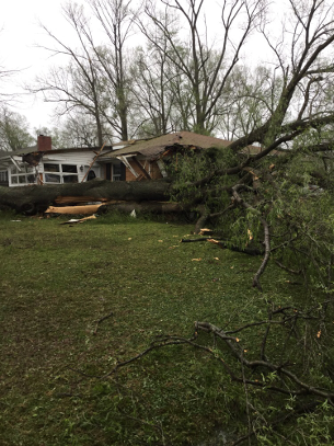
On April 21 2017, a storm with high winds struck Colonial Beach, Virginia and affected other parts of Westmoreland County, damaging 120 commercial and residential structures, and causing approximately $5 million in damage costs. Because of the implementation timeline, the local GIS and tax data had not yet been loaded into the Crisis Track software. However, the teams still used the system to conduct damage assessments with blank damage assessment forms.
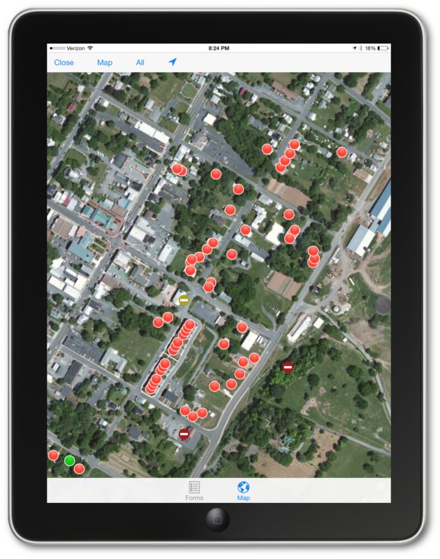
Westmoreland County officials began the damage assessment process immediately following the storm. Teams completed two phases of field operations: an initial damage assessment that night and a more thorough damage assessment after sunrise. With no tax data in the system, teams decided to conduct the initial assessment using spreadsheets instead of the Crisis Track application. The next day Crisis Track support loaded Westmoreland County address points into the system and uploaded the spreadsheet from the initial assessment. With little official training, damage assessment teams conducted a more thorough assessment using the blank damage assessment forms and address point locations on the Crisis Track mobile app. In several instances, damage assessment teams unknowingly captured duplicate assessments that were also captured from the spreadsheets in the initial assessment. County officials identified these instances and merged the data back in the office.
After the teams completed the field efforts, Westmoreland County officials identified the assessed values and calculate the damage cost for each property. Westmoreland County reported initial damage numbers to VDEM within 12 hours of the storm. However, without property values loaded in Crisis Track, these numbers only indicated initial counts by damage category and not total disaster costs. After determining property values and resolving other issues, the county completed the damage assessment by April 27.
Case Study 2: Damage Assessment Using GIS and Tax Data – Lancaster County, Virginia
Almost a month before Westmoreland County's storm, a windsheer event hit Lancaster County and several other Virginia localities on April 6, 2017. The storm damaged 54 structures in the County and caused approximately $2.8 million in damage. Unlike the damage assessment operation in Westmoreland County, the GIS-base tax data for Lancaster County was processed and loaded before the incident.
Lancaster County damage assessment teams, with VDEM support, conducted the damage assessment operation soon after the storm hit. Although the local teams had not yet received VDEM's damage assessment training, VDEM provided a 10 minute pre-brief on how to use the mobile application, then used Crisis Track to assign teams to canvass areas of reported damage. At first the damage assessment coordinator drew assigned task areas in Crisis Track for each team. However, as the EOC received more initial damage reports in other parts of the county, the damage assessment coordinator verbally assigned teams to neighborhoods to canvas to save time.
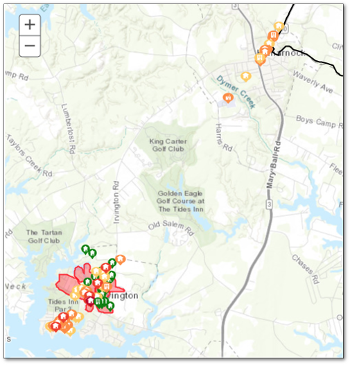
Using the Crisis Track on their mobile devices, the damage assessment teams quickly identified each property address, owner name, and improved tax value based on Lancaster County's GIS data. Then, the teams assigned a damage category, captured some notes, and took pictures. Crisis Track used the damage category to estimate a disaster cost based on the tax assessment values of that property.
After four hours the damage assessment teams completed their operations. Lancaster County did not have to perform any post operation processes before sending data to the VDEM. In fact, Crisis Track automatically transferred the data to the State's EOC. By noon County local officials had complete damage assessment summaries for the local officials and provided accurate answers to questions posed by the media. Within the State EOC, VDEM saw data for Lancaster County as well as two other localities which quickly provided summary information and reports to executives at the state. The entire damage assessment process took 5 hours.
After Action
With similar types of events, VDEM was able to measure the effectiveness of using GIS and tax data for local damage assessment operations. Having data pre-staged before the event improved the damage assessment planning, field, and post-field office processes for reporting numbers to VDEM.
More accurate results due to planning
With the Crisis Track system loaded before the incident, Lancaster County was able to quickly organize their damage assessment plan. Lancaster County's damage assessment plan used both hand-drawn areas as well as natural boundaries to organize the damage assessment teams. This helped prevent field teams from making multiple passes in one area and reduced the number of duplicate entries found in the final results. After the operations teams discussed using these natural boundaries as “pre-configure tasks”—task areas set up before the incident—to help reduce the planning time of the operation.
Quicker field work
Having local GIS structure data viewable on the mobile application map helped Lancaster County damage assessment teams more quickly locate and assess the correct structure in the field. Without the tax records on hand Westmoreland County reported having some difficulties documenting properties with multiple structures. In addition, Lancaster County damage assessment teams were able to use damage assessment forms pre-populated with address and ownership type, which reduced the amount of data elements that needed to be captured for each structure. Once they collected data in the field, the local EOC and VDEM could immediately see the disaster's extent from mapped results and intensity from overall damage costs.
Quicker, more useful results
Not needing to extensively post process damage assessment data saved Lancaster County days of effort over Westmoreland County's operation. Once teams collected data in the field, Crisis Track immediately converted the Lancaster County data into FEMA forms for local results and sent the data to VDEM for statewide situational awareness. County officials used these results to communicate the situation to the media within hours of the incident. Westmoreland County was able to quickly send preliminary results to VDEM shortly after the storm. However, the County needed several days of processing time to completely identify disaster costs.
Today both Westmoreland County and Lancaster County have GIS and tax data pre-staged for disaster operations. What these two events showed VDEM was the benefit in having GIS and tax data staged for damage assessment operations. Using this data helped local governments decrease the amount of time needed to provide VDEM with accurate disaster extents and costs. Shortening this time allowed VDEM to more quickly identify unmet needs and request disaster assistance.